Introduction to surveying drones
Surveying drones have gained popularity in recent years as modern tools for taking land surveys. With the advanced technology they offer, they are revolutionizing traditional surveying methods, enabling faster and more precise data collection. Their applications span a wide range of fields, from urban planning to agriculture, making them extremely versatile devices. In this article, we’ll take a look at how surveying drones are changing the way we look at field measurements, the benefits they bring, and the challenges they still face. We invite you to discover how modern technology can simplify and streamline surveying processes.
History and development of technology
The history of surveying drones dates back to the early days of unmanned aerial vehicle (UAV) technology, which were initially used primarily for military purposes. Over time, advances in technology allowed them to be adapted for civilian applications.
In the 1990s, the use of drones in surveying began to be explored, with the first successes in the form of accurate field measurements.
The breakthrough came at the beginning of the 21st century, when the precision of sensors was increased and advanced GPS navigation systems were introduced. Drones became more accessible and easier to use, which led to their popularization in various fields.
Nowadays, they are widely used in surveying, thanks to a combination of modern technologies such as photogrammetry and lidar, making it possible to collect field data quickly and accurately.
Application in geodesy
In surveying, survey drones play a key role in collecting field data with high accuracy and in a short period of time.
- With them, topographic mapping can be done, which is essential for urban and infrastructure planning.
- Drones equipped with high-resolution cameras and lidar sensors allow the creation of three-dimensional terrain models, which is extremely useful for analyzing landforms and their changes.
- They can also monitor the condition of infrastructure such as roads, bridges and railroads, providing up-to-date data needed to assess their condition.
- Drones are also used in precision agriculture, where they help manage water resources and fertilization.
Their versatility and ability to work in hard-to-reach places make them indispensable in modern surveying, contributing to the efficiency and accuracy of measurements.
Increase in popularity of drones
The rise in popularity of surveying drones in recent years is a result of their ability to transform traditional surveying processes into faster and more efficient operations. More and more companies and institutions are recognizing the potential that drones offer in surveying more broadly. Thanks to the increasing miniaturization of the technology, drones have become more affordable, allowing them to be used more widely, even by smaller companies. Their versatility and adaptability to different terrain conditions make them used in a wide variety of projects – from simple plot surveys to complex mapping of large areas.
In addition, growing environmental awareness and the need to minimize environmental impact are fostering their popularity, as drones reduce the emissions associated with traditional surveying methods. Thanks to all these factors, surveying drones are becoming an increasingly common tool in the arsenal of surveyors.
Advantages of using drones
Speed and efficiency of measurements
One of the main advantages of using surveying drones is that they significantly improve the speed and efficiency of field surveys. Traditional surveying methods often require a lot of time and human labor, which can be inefficient and costly. Drones, thanks to advanced technologies such as GPS and lidar, are able to scan large areas in a short period of time, providing precise data. The use of drones makes it possible to reduce the number of people needed for a project, reducing costs and increasing work safety. In addition, drones can operate in difficult terrain conditions, where traditional surveying methods may be risky or unfeasible. This makes it possible to map terrain quickly and accurately, which is extremely useful in fast-paced construction and infrastructure projects where turnaround time is crucial.
Accuracy and precision of data
Survey drones stand out for their extreme accuracy and precision in collecting field data, making them an invaluable tool in modern surveying. Equipped with advanced sensors such as lidar and high-resolution cameras, drones are capable of capturing detailed terrain information that is crucial for precise mapping and analysis. They make it possible to create detailed three-dimensional models that accurately reflect the actual terrain.
The precision of drone measurements minimizes the risk of human error that can occur with traditional methods. Additionally, the ability to take measurements from the air eliminates the need for physical access to hard-to-reach areas, which increases safety and efficiency. As a result, the data collected by drones is not only accurate, but also more reliable, which is crucial for making design and planning decisions.
Safety and accessibility of difficult areas
Survey drones significantly improve safety during surveying projects, especially in difficult and dangerous areas. With their ability to take measurements from the air, they eliminate the need for people to be physically present in potentially dangerous areas, such as steep slopes, swamps or flood plains. Drone operations minimize the risk of accidents and injuries, which is key to protecting the health of workers.
Drones also provide access to areas that may be difficult to access or impossible to survey using traditional methods. Their ability to traverse terrain obstacles and fly at high altitudes enables precise mapping of even the most challenging areas.
This allows surveying projects to be completed faster and more safely, resulting in more efficient and accurate surveys, as well as saving time and resources.
Technologies in surveying drones
Cameras and sensors
Survey drones are equipped with advanced cameras and sensors that allow precise field data collection.
High-resolution cameras enable detailed images to be taken that form the basis for accurate maps and 3D models. With photogrammetry technology, these images can be processed to produce precise measurements and terrain analysis.
In addition to cameras, drones are often equipped with lidar sensors that use laser pulses to measure distance. Lidar is particularly useful in mapping forested areas, where precise data is difficult to obtain using conventional methods. Other sensors, such as thermal imaging, can be used to detect changes in heat, which is useful for monitoring infrastructure.
These advanced technologies in surveying drones ensure not only high data accuracy, but also the ability to collect data quickly and efficiently in a variety of field conditions.
Navigation and control systems
Navigation and control systems are a key component of geodetic drones, enabling precise planning and execution of aerial missions.
- Modern drones are equipped with advanced GPS receivers that provide accurate real-time positioning. This allows drones to move along preplanned routes with extreme precision, which is essential for effective data collection.
- In addition, navigation systems often work in conjunction with other sensors, such as gyroscopes and accelerometers, allowing for stable and controlled flight even in difficult weather conditions.
- The drone can be controlled from a pre-programmed route or by remote control, giving the operator the flexibility to customize the flight to suit current needs.
These advanced navigation and control systems significantly improve the efficiency and safety of surveying operations, while enabling the collection of accurate and reliable field data.
Data analysis software
Data analysis software plays a key role in the use of surveying drones, enabling the processing and interpretation of the information collected. Once the drone is flown, the data from the sensors and cameras are sent to specialized software that allows for accurate analysis.
- Photogrammetric software converts images into three-dimensional terrain models, enabling detailed mapping and measurements.
- Lidar programs, on the other hand, process laser data to produce precise elevation maps.
- In addition, GIS (Geographic Information Systems) software allows integration of data from different sources, which is invaluable in complex surveying projects.
Thanks to advanced analytical tools, surveyors can interpret the collected data faster and more accurately, resulting in better project planning and execution. These innovative technological solutions significantly simplify analysis processes, making them more efficient and accurate.
Practical applications in the field
3D mapping and modeling
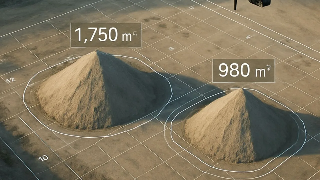
3D mapping and modeling with surveying drones is revolutionizing the way we analyze and interpret geographic space. Drones, equipped with state-of-the-art cameras and sensors, take aerial photos, which are then processed into detailed 3D models of the terrain. Such models offer an accurate representation of topography, which is invaluable for urban planning, construction or natural resource management.
Thanks to lidar technology, drones can capture even fine details of landforms, which is crucial for geological or architectural analysis. 3D models also make it possible to visualize infrastructure projects, such as roads or bridges, making it easier to plan and optimize investments. In addition, 3D mapping is extremely useful in monitoring environmental changes, such as soil erosion or deforestation, providing valuable data for environmental research and protection.
Inspection of infrastructure
Survey drones play a key role in infrastructure inspection, offering a quick and safe way to assess the condition of various structures. Equipped with high-quality cameras and sensors, drones can accurately monitor bridges, roads, railroads, as well as buildings and other structures. With the ability to fly at high altitudes and in hard-to-reach areas, drones eliminate the need for traditional inspection methods such as scaffolding or cranes, significantly reducing risks to workers and operational costs.
Drones can also respond quickly to sudden inspection needs after events such as storms or earthquakes, providing immediate data for damage assessment. Inspections with drones are more efficient and can be performed more frequently, allowing for early detection of problems and prevention of more serious failures, increasing the sustainability and safety of infrastructure.
Natural resource management
Survey drones are becoming an invaluable tool in natural resource management, providing precise data that supports environmental protection and sustainable resource management. With the ability to efficiently monitor large areas, drones enable detailed mapping of forests, rivers, lakes and other ecosystems. Such mapping helps track changes in the environment, such as deforestation, soil erosion and changes in water levels, which is crucial for making conservation decisions.
Drones can also monitor vegetation health, identifying areas in need of intervention, which is particularly useful in precision agriculture. In the water sector, drones help manage water resources by providing accurate data on water quality and river conditions. With these capabilities, drones contribute to more efficient and sustainable management of natural resources, supporting environmental protection efforts.
Challenges and the future of drones
Regulations and security
One of the significant challenges in the development of surveying drones is regulatory and safety issues. In many countries , regulations for drone use are still under development, which can create legal uncertainty for operators and companies. These regulations often include rules on drone registration, operator licensing, as well as restrictions on flight altitudes and zones in which drones can be used.
In addition, ensuring safety during drone operations is crucial, especially in populated areas where there is a risk of collision with other objects. Operators must be properly trained to effectively manage drones and minimize the risk of accidents. As drone technology develops and becomes more widespread, further development and adaptation of regulations is needed to ensure the safe and legal use of these advanced tools in surveying and other fields.
Technology development and innovation
The future of surveying drones is being shaped by rapid technological developments and innovations that can greatly expand their capabilities. As technology advances, drones are becoming more advanced, offering better energy efficiency, greater durability, and increased precision in surveying.
- New developments, such as artificial intelligence and machine learning, can further automate data collection and analysis processes, making surveying work faster and more efficient.
- Innovative technologies, such as 5G connectivity, can improve drones’ communication capabilities, enabling them to operate in a more coordinated and integrated manner.
- In addition, the development of composite materials could lead to lighter and more durable drones.
These technological advances are opening up new opportunities for drone applications in various sectors, such as construction, agriculture and environmental protection, helping to further revolutionize the way we use these devices in surveying and beyond.
The future in surveying and beyond
The future of drones in surveying and other fields looks extremely promising, thanks to their versatility and potential for integration with other technologies.
In surveying, drones will continue to play a key role in streamlining and speeding up surveying processes while offering greater accuracy and safety. The ability to integrate drones with GIS systems and advanced analytical algorithms opens up new perspectives in spatial data analysis.
In addition to surveying, drones are increasingly used in areas such as logistics, where they can support deliveries in hard-to-reach locations, and in precision agriculture, where they help monitor and optimize crops. In addition, in emergency services, drones can be used to respond quickly to emergency situations.
As technology continues to evolve, drones will become increasingly integrated into everyday processes, contributing to greater efficiency and innovation in many areas of life.
Free E-book
Learn proven methods for pricing jobs: From building structures to large linear and space raids. This guide will help you earn effectively and confidently.
Table of Contents:
Do you like the article? Share it with others!
Do you like the article? Share it with others!
Tips, news, insights
Related articles
Check out our articles and get the latest industry news.


")
")

")
")