Introduction to drones in measurement
Drones have grown in popularity in recent years not only as gadgets for fun, but also as tools for professional applications. One area where drones have revolutionized traditional methods is volume measurement. They have made the process faster, more precise and accessible to a wider range of users. In this step-by-step guide, we’ll take a look at how drones can be used to calculate volume, discussing both the technology and the practicalities of doing so. We invite you to discover how modern technology is changing the approach to measurement for the better.
History and development of drone technology
Drone technology has its roots in the 1940s, when the first unmanned aerial vehicles were used for military purposes. Since then, the technology has come a long way, evolving into commercial and civilian applications.
As technology has advanced, drones have become smaller, lighter and more advanced, which has contributed to their popularization in various industries. In particular, in the field of volumetric surveying, drones have begun to play a key role, enabling fast and accurate data collection over large areas. Thanks to integration with modern GPS systems and advanced
Application of drones in various industries
Drones have found their way into many industries, helping to improve the efficiency and precision of tasks.
In agriculture, drones make it possible to monitor crops so that they can respond quickly to changing weather conditions or threats from pests.
In construction and mining, drones are being used to measure material volumes and terrain, eliminating the need for manual inspections at high altitudes or hard-to-reach areas.
In addition, drones are used in public safety, where they help monitor large areas and in search and rescue operations. Their ability to move quickly and collect data in real time makes them indispensable in emergency situations.
Thanks to their versatility, drones are becoming an integral part of modern technology in many sectors of the economy.
Basic benefits of using drones
The use of drones in surveying and other applications brings numerous benefits that make them an attractive choice for many industries.
First of all, drones offer much faster data collection compared to traditional methods, which contributes to saving time and resources. Thanks to the high precision of measurements, drones minimize the risk of human error, which is crucial in industries such as construction and surveying.
In addition, drones can operate in hard-to-reach locations, increasing worker safety by eliminating the need for a physical presence in dangerous areas. Their ability to collect real-time data allows for quick decisions, which is invaluable in situations that require immediate response. Finally, drones are often more cost-effective in the long run, reducing operational costs associated with traditional surveying methods.
Volume measurement process with drones
Preparation of hardware and software
The first step in the process of volume measurement with drones is the proper preparation of hardware and software. It is essential to choose the right drone that meets the requirements of a specific task:
- It is important that the drone is equipped with a high-quality camera or sensor to ensure the accuracy of the data collected.
- Next, you need to configure the flight mission planning software to program the drone’s flight path and determine the measurement parameters.
- It’s also a good idea to make sure your data processing software has features that allow you to analyze and calculate volumes based on the collected data.
- Before launching an air mission, it is important to test the equipment and check the weather conditions to ensure the safety of the operation and the best possible quality of the data collected.
Collecting data in the field
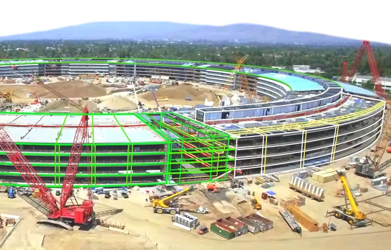
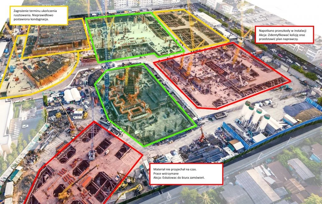
Collecting data in the field is a key step in the drone volume measurement process. Once the hardware and software are prepared, the drone is ready to carry out the planned mission. During the flight, the drone collects visual data using a camera or LiDAR sensor, which are then used to create 3D models of the terrain. It is important that flights are carried out in stable atmospheric conditions to minimize the risk of interference and ensure the highest quality of data. The drone operator should monitor the flight path and technical parameters in real time to make adjustments if necessary. Once the mission is completed, the data is sent to the software for further analysis. Accurate data collection is essential to generate accurate models, which can then be used for volumetric calculations, which is crucial to the success of the entire project.
Analysis and interpretation of results
Once the data is collected in the field, the analysis and interpretation stage of the results follows, which is crucial for obtaining accurate volume measurements. The data from the drone is imported into specialized software that converts the images or LiDAR data into 3D models. From these models, the volume of specific objects or sites can be calculated using advanced spatial analysis algorithms. It is important to pay attention to the quality of the data and any errors that may affect the final results. With 3D visualization, users can easily interpret the results and make informed decisions. Data analysis identifies key areas that may require detailed evaluation. Finally, the results of the measurements are documented and can be used for further analysis or reporting, making the process of volume measurement using drones not only precise, but also practical.
Technical aspects of drone measurements
Choosing the right drone and sensors
Choosing the right drone and sensors is crucial to the success of volumetric measurements. The drone should be tailored to the specific task and field conditions in which it will operate. Important criteria are flight range, battery life and stability in harsh weather conditions.
Sensors, such as high-resolution cameras or LiDAR technologies, must ensure the accuracy and detail of the data collected. Depending on your needs, the choice may fall on RGB sensors for high-quality imagery, or multispectral for agricultural analysis.
Also, memory capacity and data transmission capabilities should be taken into account to ensure smooth operation.
A properly selected set of hardware and software allows optimizing the data collection process and meeting specific design requirements, which is essential for accurate and reliable results.
Calibration and measurement accuracy
Calibrating drones and their sensors is crucial to ensuring the accuracy of volumetric measurements. The process involves adjusting the equipment to the operating conditions and eliminating potential errors that could affect the results. Calibration includes, but is not limited to, setting up the camera, synchronizing data with GPS, and testing the sensors to ensure they are working properly.
Regular checking of hardware and software is essential to minimize the impact of external factors such as changes in temperature or humidity.
The accuracy of the measurements can also be improved by applying advanced correction algorithms and using checkpoints in the field. This makes the data more reliable and can be used for precise analysis.
Calibration and measurement accuracy are integral components of professional drone operations that affect the quality and efficiency of the data collected.
The future of drone survey technology
The future of drone survey technology looks promising, with many innovations on the horizon that can further improve data collection and analysis processes.
- The development of artificial intelligence and machine learning can significantly increase the automation and precision of measurements, allowing drones to make decisions on their own in real time.
- In addition, advances in miniaturization and sensor performance will allow even more accurate data collection while reducing the weight and cost of the equipment. Integration of drones with cloud systems will enable seamless data flow and analysis from anywhere in the world.
- The development of 5G technology, in turn, could revolutionize the speed and range of data transmission, making drone operations more efficient.
These innovations can not only improve the accuracy of measurements, but also open up new possibilities for drone applications in various industries, making them an even more versatile tool of the future.
Practical applications and examples
Measurements in construction and mining
Drones are playing an increasingly important role in the construction and mining industries, providing efficient and accurate survey solutions. With the ability to conduct inspections from the air, drones can quickly and safely collect volume data on materials such as soil, aggregates and other raw materials.
In the construction industry, drones make it possible to monitor progress on a construction site, identify potential problems and conduct site inventories. This optimizes logistics processes and reduces operational costs.
In the mining industry, drones are used to map pits, allowing for precise mine planning and minimizing the risks associated with working in harsh conditions.
With advanced data analysis software, measurement results can be quickly processed and interpreted, increasing the efficiency of operations and enabling better-informed decision-making in these key industries.
Natural resource management
Drones are increasingly being used in natural resource management, offering state-of-the-art tools for environmental monitoring and protection. With advanced sensors and the ability to collect data from hard-to-reach areas, drones enable precise mapping of forested, agricultural or water areas. This makes it possible to assess the condition of resources such as forests, farmland or water bodies, which is crucial for sustainable management and environmental protection.
In agriculture, drones can monitor plant health, identifying areas in need of intervention, leading to optimization of fertilizer and pesticide use.
In water management, drones help monitor water levels and reservoir quality, which is essential for water conservation.
Integration of drone data with GIS systems enables the creation of comprehensive spatial analysis, supporting decision-making related to natural resource management.
Applications in precision agriculture
Precision agriculture uses drones as tools to increase efficiency and precision in crop management. Drones equipped with multispectral sensors can quickly and accurately monitor the health of plants over large areas. This allows farmers to identify water stress, nutrient deficiencies or disease incidence. The drones also make it possible to map field variability, allowing agricultural practices to be tailored to the specific needs of individual zones. Precise drone data helps optimize irrigation, fertilization and pesticide use, leading to increased yields and reduced costs. As a result, agriculture is becoming more sustainable and environmentally friendly. In addition, drones can be used to monitor livestock, facilitating pasture management. By integrating with farm management systems, drone data supports decision-making and helps improve the profitability of precision agriculture.
Challenges and the future of drone surveying
Legal restrictions and regulations
Legal restrictions and regulations are a significant challenge to the use of drones for volumetric measurements. Drone laws vary from country to country and can include restrictions on flight altitudes, areas that can be flown over, and operator license requirements. In many places, special permits must be obtained for commercial flights, especially near airports or built-up areas.
Drone operators also need to be aware of privacy laws to avoid violating citizens’ rights. Adapting to changing regulations requires staying abreast of legal updates and working closely with regulators. Despite these challenges, regulations are designed to ensure safety in the airspace and protect privacy, which is essential for the sustainable development of drone technology. In the future, more harmonized regulations may facilitate wider use of drones in various industries.
Security and data protection
Security and data protection are key aspects to consider in the context of drone surveys. Drones collect vast amounts of data, which can include sensitive information about location, infrastructure or private properties. Ensuring that this data is stored and processed securely is essential to protect against unauthorized access and potential cyberattacks.
Organizations using drones must implement advanced security measures, such as data encryption and access authorization. It is also important for operators to be aware of data protection and privacy regulations, such as the European Union’s RODO. As drone technology evolves, data security methods must also be regularly updated to meet new challenges. This ensures user confidence and supports the continued development of drone technology in a responsible and secure manner.
Innovations and future developments
Innovations in drone technology continue to expand the horizons of its applications, and future developments promise even greater possibilities.
- One key area is the integration of drones with artificial intelligence and machine learning technologies, which will allow for more autonomous operations and better real-time data analysis.
- Developments in sensor technology, such as LiDAR and thermal imaging cameras, will enable even more detailed and precise data collection, which is particularly important in environmental monitoring and critical infrastructure.
- In addition, advances in connectivity, including 5G technologies, will revolutionize data transmission, enabling more complex analysis and faster responses to changing conditions.
These innovations will not only increase the efficiency and accuracy of drone surveys, but also open up new opportunities for their use in various sectors, from agriculture to natural resource management and urban planning.
Free E-book
Find out how UAV and AI support investment supervision, facilities management and the daily work of engineers. Learn about real-world applications of technology in construction and real estate.
Table of Contents:
Do you like the article? Share it with others!
Do you like the article? Share it with others!
Tips, news, insights
Related articles
Check out our articles and get the latest industry news.


")
")

")
")