Introduction
The market for drone services is growing rapidly, but competition is increasing. Standing out requires not only the quality of images and measurements, but also skillful communication of the benefits the customer receives from a particular product.
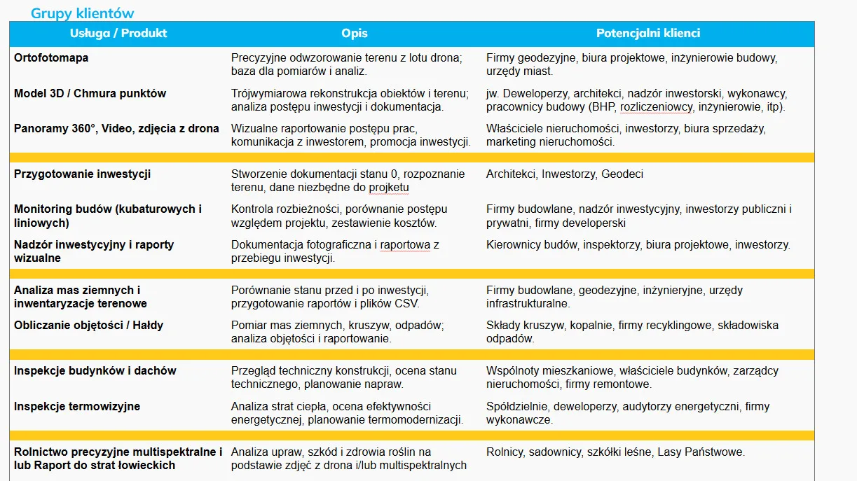
1. orthophotomap – the foundation of measurement and analysis
What to advertise:
Orthophotomap is a precise, calibrated photograph of the area that perfectly represents reality.
Key messages for the customer:
- Ideal for measuring and planning.
- More up-to-date than Geoportal data or public resources.
- Basis for projects and analysis.
- Quick update after each stage of the investment.
Major industries:
- surveying companies
- design offices
- construction engineers
- municipalities
How to advertise:
- “Measurement accuracy up to XX cm.”
- “I provide GIS- and CAD-ready material.”
- “I update the site before design and before tenders,” he said.
Graphic proposals:
- comparison of orthophotos with the plot map
- CAD overlay → orthophoto (before/after)
2. 3D model / point cloud – full terrain reconstruction
What to advertise:
3D models and point clouds support investment, documentation and progress comparison.
Key messages:
- Accurate geometry of objects and terrain.
- Project collision control.
- Shipping in formats: LAS, OBJ, PLY, DXF, etc.
- Ideal for investors – the ability to watch online (e.g., in SkySnap Viewer).
Major industries:
- developers, architects
- construction managers and inspectors
- contractors
- health, safety and billing companies
How to advertise:
- “Full 3D model for comparison with design or BIM.”
- “‘as-built’ report available online for investor.”
Graphic proposals:
- viewer point cloud
- comparison of state 0 and current model
3. 360° panoramas, video and drone shots – visual communication of investments
What to advertise:
Visual material supports sales, communications and reports.
Key messages:
- Transparent communication with the investor.
- Increased credibility in the eyes of buyers and partners.
- Perfect marketing material.
Major industries:
- property owners
- real estate sales and marketing offices
- investors
How to advertise:
- “An up-to-date 360° view of investments for clients.”
- “Professional shots for listings, advertisements and investment pages.”
Graphic proposals:
- panorama with marked points
- aerial photo of the plot with described boundaries
4. state 0 documentation – investment preparation
What to advertise:
The start of any investment requires reliable documentation of the site.
Key messages:
- Complete data set for the project.
- Comparison of the state before and after the investment.
- Quick verification of field conditions.
Major industries:
- architects
- investors
- surveyors
How to advertise:
- “Complete data for design development.”
- “Field report ready for investment decisions.”
Graphic proposals:
- a photo of the site with the indication of the future investment
- measurements + state orthophoto 0
5. monitoring of construction sites – cubic and linear
What to advertise:
Regular raids as a basis for investment control.
Key messages:
- Comparison with schedule.
- Early detection of deviations.
- Cost and progress reports.
Major industries:
- construction companies
- investment supervision
- public and private investors
- developers
How to advertise:
- “I report on the progress of investments on a weekly/monthly basis.”
- “I integrate photos and models into your management system.”
Graphic proposals:
- board “month by month”
- the route of the linear investment

Free E-book
Learn how to prepare a mission step-by-step, avoid raid mistakes and create accurate orthophotos and 3D models. The perfect guide before your first commercial assignments.
6. investment supervision and visual reports
What to advertise:
Full photo and video documentation of the investment.
Key messages:
- Evidence for contractors and inspectors.
- Facilitated billing and collections.
Major industries:
- site managers
- superintendents
- design offices
- investors
How to advertise:
- “A complete visual log of the investment.”
- “Full comparison with the project and acceptance documentation.”
Graphic proposals:
- PDF report with element control
- photos before/after stage acceptance
7. earth mass analysis and field inventories
What to advertise:
Precision land surveys based on 3D models.
Key messages:
- CSV, DXF, comparison reports.
- Information necessary for planning and billing.
Major industries:
- construction companies
- surveyors
- infrastructure offices
- engineering companies
How to advertise:
- “Pre- and post-investment measurement with cm accuracy.”
- “Report for design and environmental purposes.”
Graphic proposals:
- cross sections
- terrain model with color legend of height differences
8. volume measurement – heaps, aggregates, waste
What to advertise:
Drones are faster, safer and more accurate than classic methods.
Key messages:
- High accuracy (deviations of a few percent).
- Documentation for billing.
- Saving time and safety.
Major industries:
- aggregate stockpiles
- mines
- recyclers
- landfills
How to advertise:
- “Measuring heaps without entering a hazardous area.”
- “PDF report + data to Excel.”
Graphic proposals:
- heap height map
- volume before/after material displacement
9. building and roof inspections
What to advertise:
Drones provide quick technical inspection and access to hard-to-reach areas.
Key messages:
- Identification of damage, corrosion, leaks.
- Material for renovation companies and managers.
- Without going up to the roof.
Major industries:
- housing communities
- building owners
- property managers
- renovation companies
How to advertise:
- “Full fault report + close-up photos.”
- “Inspection without scaffolding and jacks.”
Graphic proposals:
- damage details
- photo of the entire roof with markings
10. thermal imaging inspections
What to advertise:
Drones reveal heat loss and energy problems.
Key messages:
- Analysis of thermal bridges and insulation.
- Reports for energy auditors.
- Basis for Thermal Modernization.
Major industries:
- cooperatives and communities
- developers
- energy auditors
- construction companies
How to advertise:
- “Rapid identification of energy losses.”
- “Thermal statement of the entire facility.”
Graphic proposals:
- RGB photo next to thermal photo
- heat loss map
11. precision agriculture and hunting damage reports
What to advertise:
Multispectral drone imagery can assess plant health, diagnose problems and document damage.
Key messages:
- Crop health analysis.
- NDVI, NDRE, other indicators.
- Reports for State Forests and hunting clubs.
Major industries:
- farmers
- fruit growers
- forest nurseries
- State Forests
How to advertise:
- “Early detection of diseases and deficiencies.”
- “Accurate documentation of wildlife damage.”
Graphic proposals:
- NDVI map
- comparison: healthy vs damaged crops
Summary: How to sell drone services more effectively?
- Always show specific benefits, not just technique.
- Match the message to the industry, not the equipment.
- Show examples of the end results – preferably online in SkySnap Viewer.
- Combine services into packages (e.g., “monitoring + orthophoto + 3D model”).
- Add visualizations and reports – make it easier for the customer to decide.
Add your implementations to SkySnap – get a head start on sales
SkySnap portal allows you to prepare in a few minutes:
- interactive reports for customers
- presentation of 3D, orthophoto, 360° works, models and photos
- links that you can send to the customer instead of heavy files
No fee, no obligation, no card – you can test and show customers your designs.
Table of Contents:
Do you like the article? Share it with others!
Do you like the article? Share it with others!
Tips, news, insights
Related articles
Check out our articles and get the latest industry news.


")
")

")
")