Drone use in surveying: How drones are changing the face of surveying – Modern Technologies in Practice – SkySnap
The use of drones in surveying is becoming increasingly common, changing the way professionals collect and analyze field data. Thanks to modern technologies, these unmanned aerial vehicles offer fast and precise solutions in surveying, which previously required considerable time and effort. The use of drones makes it possible to obtain detailed maps and terrain models with unprecedented accuracy, revolutionizing planning and construction processes. In this article, we take a look at how drones are impacting the surveying industry and the benefits they bring to professionals and investors. Get ready to discover how modern technologies are transforming traditional surveying methods into a more efficient and cost-effective approach. The introduction of drones into surveying has brought significant benefits, increasing the efficiency and precision of measurements.
Introduction to drones in surveying
History and development of drone technology
The history of drones dates back to the 1950s, when they first began experimenting with unmanned aerial vehicles for military purposes. Initially, they were mainly used for reconnaissance tasks. With advances in technology and the miniaturization of components, drones began to find applications in other fields as well.
The 1990s and 2000s saw the rapid development of drone technology, allowing them to be commercialized and available to a wide range of users. They began to see their potential in surveying, where the ability to take precise measurements from the air brought about a revolution. Drones have gradually become an indispensable tool in the work of surveyors, offering modern methods of data collection that are both more efficient and cost-effective compared to traditional methods. Drones used in surveying contribute to increasing the precision of measurements and the efficiency of surveyors’ work.
Fundamentals of drone surveying
Drone surveying is the use of drones to collect terrain data from the air. The process involves several key steps: flight planning, data recording, and data analysis.
Flight planning is critical because it requires determining optimal routes and the altitude at which the drone will travel to obtain accurate terrain data.
The drone then takes flight, capturing images and other data using advanced sensors such as RGB cameras, multispectral cameras and LiDAR scanners.
The data collected in this way is then processed using photogrammetry software, which makes it possible to create three-dimensional terrain models and precise maps. Data processing is carried out using specialized software, making it possible to create precise maps, terrain models and orthophotos.
Thanks to its versatility and precision, drone surveying is becoming an indispensable tool for surveyors, offering a modern and efficient approach to land surveying.
Advantages of using drones in surveying
Accuracy and efficiency
Drones in surveying offer unprecedented accuracy and efficiency in collecting field data. Thanks to modern sensors and advanced software, it is possible to obtain very precise measurements in a short time. Traditional surveying methods, such as ground surveys, often require many hours of work and a large team of specialists. Drones eliminate these needs, completing tasks faster and with less human resources.
Survey accuracy is a key aspect in planning drone flights in surveying, affecting the quality of the data collected. In addition, drones are able to reach hard-to-reach places, which is especially useful for areas with complex topography. The automation of the data collection process minimizes the risk of human error, which translates into higher quality data obtained. As a result, drones not only increase the precision of measurements, but also significantly reduce the costs associated with surveying projects.
Cost and time reduction
The use of drones in surveying significantly contributes to reducing costs and time for projects. Traditional surveying methods often require the use of expensive equipment and the involvement of a large team of specialists, which generates high operating costs. Drones, on the other hand, make it possible to carry out surveys with less manpower and equipment. Thanks to their ability to quickly fly over large areas, drones reduce the time needed to collect data, which is particularly important in the case of vast or hard-to-reach areas. Drones are able to quickly and accurately collect data over large areas, making them an invaluable tool in surveying.
In addition, automating the surveying process reduces the risk of repeat site visits, which also saves time and money. As a result, drones are becoming an increasingly popular tool in surveying, offering efficient and cost-effective solutions that meet the needs of investors and professionals in a more affordable and flexible manner.
Practical applications of drones
Site map and analysis
Drones play a key role in land mapping and surveying data analysis. They provide detailed images and three-dimensional models of areas, which are essential for accurate planning and implementation of construction or infrastructure projects. The use of drones makes it possible to quickly and accurately map the topography of an area, which is crucial in the design process.
Aerial photogrammetry, a technique for processing photographs taken from the air, makes it possible to create digital elevation models that are invaluable for spatial analysis and evaluation of terrain conditions. The process of creating spatial models and orthophotos requires sophisticated data analysis software, which is important for accurate results in surveying and mapping. Drones can also collect the data needed to analyze soil properties, which helps identify potential geotechnical problems. Their versatility and accuracy make them an indispensable tool in the hands of surveyors and planners, offering new opportunities in land management and planning.
Monitoring environmental changes
Drones are becoming an indispensable tool in monitoring environmental change, offering a fast and accurate way to observe areas on a large scale. Their ability to capture high-resolution images from the air makes it possible to track changes in ecosystems, such as deforestation, soil erosion and shoreline changes. Thanks to modern technology, drones can be equipped with multispectral and thermal imaging cameras to help analyze vegetation health and detect climate-related temperature anomalies. Regular monitoring with drones allows rapid response to adverse changes, which is crucial for environmental protection and sustainable development.
In addition, the collected data can be used by scientists and decision-makers to create strategies for managing natural resources. In this way, drones contribute to a better understanding of dynamic processes in the environment.
Hard-to-reach areas vs. drones
Surveying drones are particularly useful for measurements in hard-to-reach areas. The use of drones makes it possible to obtain data from areas that are difficult for surveyors to access, such as tall buildings, bridges or mountainous areas.
With drones, it is possible to take measurements in a short period of time, speeding up construction projects and other developments. The use of drones in surveying also makes it possible to obtain high-resolution data, which is especially important for precise measurements.
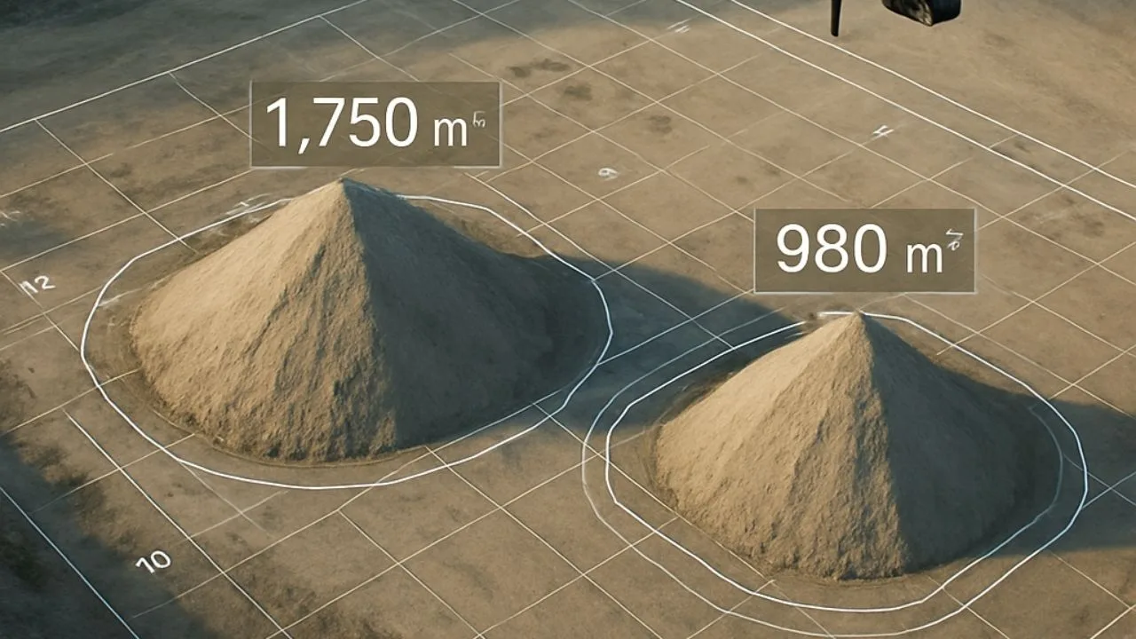
Precision measurements with drones
Surveying drones are equipped with modern technologies that make it possible to obtain precise measurements. The use of drones makes it possible to obtain data with an accuracy of several centimeters, which is especially important for construction projects and other developments where precise measurements are essential. Drones are also equipped with RTK systems that allow real-time data to be obtained, speeding up projects.
Challenges and the future of technology
Technical and legal obstacles
The use of drones in surveying faces a number of technical and legal obstacles that can challenge their widespread use.
- Technical barriers include limited battery life, which affects the amount of time a drone can spend in the air, and limitations related to GPS signal quality in difficult terrain.
- In addition, accurate processing of collected data requires sophisticated software and proper training of operators, which can generate additional costs.
- From a legal standpoint, drone flight regulations are often complicated and vary from country to country. They require special permits, adherence to unmanned zones and third-party privacy. These regulations can limit operational capabilities and affect drone mission planning.
Despite these challenges, technological advances and regulatory adaptations are creating prospects for increasing drone use in the future. In addition, surveying by drone is characterized by high precision and work efficiency, making it an attractive solution for many applications.
Innovations and future developments
The future of drone technology in surveying promises to be promising, thanks to rapidly developing innovations.
One of the main areas of progress is improving the autonomy of drones, which will allow them to fly more efficiently without the need for constant operator supervision.
Developments in artificial intelligence and machine learning are enabling drones to analyze data in real time, increasing their potential to quickly assess field situations.
In addition, the introduction of more advanced sensors, such as LiDAR with increased precision, opens up new opportunities for detailed data collection.
Future innovations may also include the integration of drones with other technologies, such as the Internet of Things (IoT), to enable better management and analysis of surveying data.
As regulations adapt to the rapid development of this technology, we can expect to see more and more drone use in various sectors of the economy.
Summary of drone impact
Key changes in the industry
Drones have had a significant impact on the surveying industry, bringing key changes to the way professionals collect and analyze field data.
Above all, the automation and precision offered by drones have transformed traditional surveying methods, making them more efficient and cost-effective. As a result, surveying projects can be completed faster and at a lower cost, which is important in the context of growing market demands.
Drones have also enabled better access to hard-to-reach areas, which had previously been a challenge for surveyors.
The introduction of drone technology has increased safety by eliminating the need to work in dangerous conditions.
In addition, the ability to generate accurate three-dimensional models and maps has increased the quality of spatial analysis.
All these changes have not only improved the industry’s performance, but also opened up new opportunities for future innovation and technological development.
The future of surveying in the drone age
The future of surveying in the drone era promises to be a time of dynamic change and innovation. Drones, with their versatility and precision, are becoming an integral part of modern surveying technologies. As technology advances, drones will become even more integrated into surveying processes, enabling more complex analysis and real-time data processing.
- The ability to quickly acquire and update field data will support the development of smart cities and the management of natural resources.
- With the development of artificial intelligence, drones will be able to automatically identify key changes in the topography of a site, which will contribute to even better urban planning.
- In addition, the increasing availability and falling cost of drone technology will make it possible for even smaller companies and independent surveyors to take advantage of these advanced tools.
- Ultimately, drones will transform surveying into a more integrated, sustainable and efficient field. The process of creating three-dimensional terrain models involves taking aerial photos from a drone, which is important for investment planning and hazard analysis.

Free E-book
Learn what services to offer, who to sell them to, and how to write an effective offer email. Ready-made templates, tips and examples of campaigns that really work.
Table of Contents:
Do you like the article? Share it with others!
Do you like the article? Share it with others!
Tips, news, insights
Related articles
Check out our articles and get the latest industry news.


")
")

")
")