Introduction to drones in construction
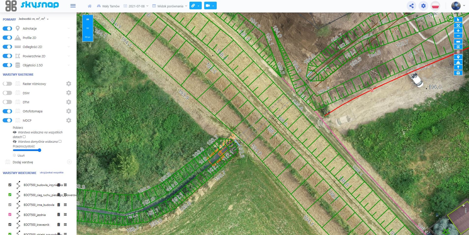
The introduction of drones in the construction industry is becoming increasingly popular, especially for large infrastructure projects. The use of drones allows for the rapid and accurate acquisition of data that is essential for the design and construction of structures. Drones are equipped with specialized cameras and sensors that enable the collection of terrain data, including orthophotos and point clouds. This data can be used to create accurate 3D models of the site, which is particularly useful in case of disputes with subcontractors.
Application of drones
The use of drones in construction is extensive. They can be used at every stage of construction, from design to completion. Drones make it possible to quickly identify problems and dangerous situations, which is key to improving safety on the construction site. The use of drones also makes it possible to increase the productivity and efficiency of the work, which translates into financial savings. The construction company can use drones to monitor the progress of the work, allowing it to quickly detect potential problems and irregularities.
Orthophotomap from a drone – fast and simple in a web browser!
Orthophotos from a drone are not just impressive aerial photos. Obtaining the necessary conditions and permits is crucial for drone projects. With modern tools, you can now create advanced maps and terrain models, all easily, right in your web browser. Learn how you can use these technologies to gain time, improve team communication, and enhance the quality of your services with highly accurate drone data.
Develop your competencies and earn more
Do you take photos and videos from a drone? Would you like more? Do you have a drone? Develop your competence and earn more! Wondering how to do it? Start with orthophotos from a drone. With it you can increase your offerings and attract new customers. Drones are increasingly being used in various construction projects, offering accurate surveying data and allowing you to effectively monitor the progress of the work. Companies such as Budimex, Astaldi and Skanska are using drones to increase the efficiency of their projects, from data acquisition to inspections.
Do you want to make money making maps?
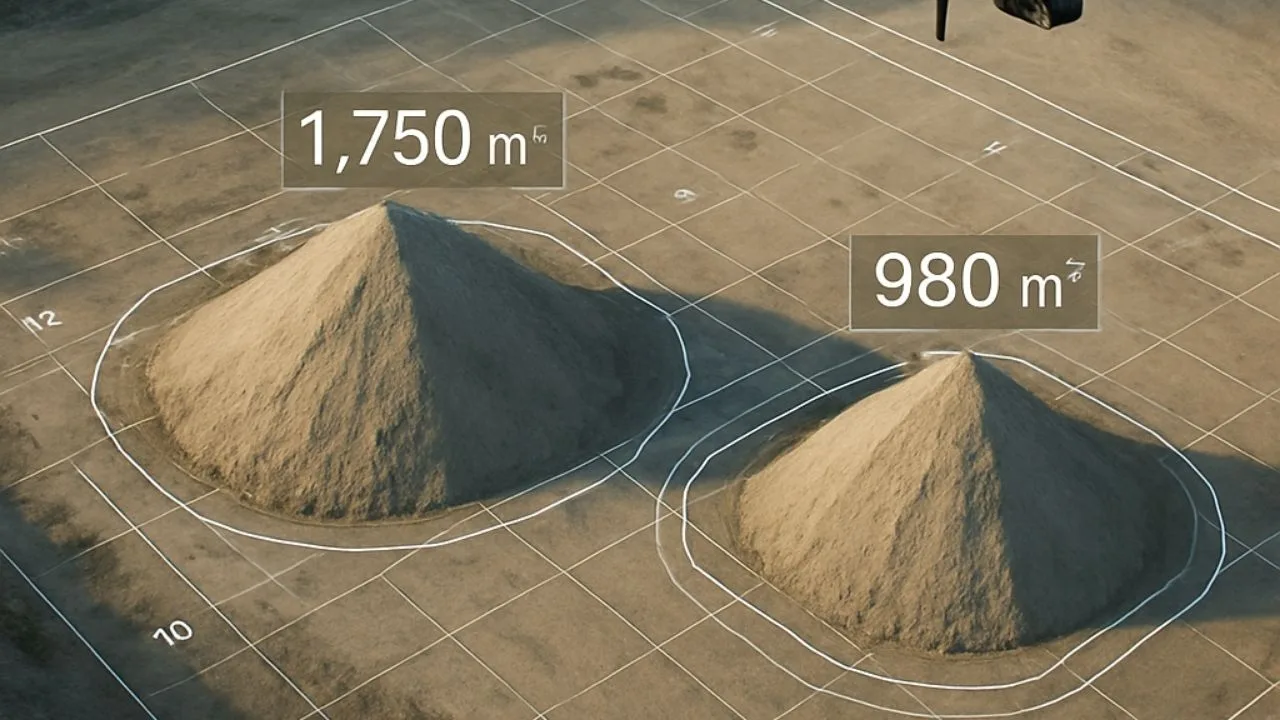
Do you have a drone and want to start making money by mapping construction sites? Drones equipped with specialized multispectral cameras and integrated thermal imaging cameras can effectively support construction-related processes through accurate measurements and cost control. In this article, we will show how you can easily start creating orthophotos and other photogrammetric studies that you can share with clients in the cloud.
How to perform a photogrammetric raid?
I have a drone and want to start doing photogrammetric raids, but I don’t know how to go about it. Check out our step-by-step guide that will walk you through the process.
Orthophotos from a drone in the cloud – check out the benefits
When performing photogrammetric studies, you have probably encountered the problem of transferring gigabytes of data to clients. Automating and optimizing the processes involved in managing this data can significantly increase productivity and efficiency. Orthophotos, numerical terrain models, and point clouds are often large data sets. Sharing them with clients can be cumbersome, especially if you have to use external platforms such as Google Drive. What’s more, clients often have trouble displaying the results of studies in their respective programs, leading to additional problems and frustration. With modern technologies such as VR, employees can be better prepared to deal with dangerous situations, which improves workplace safety.
An orthophotomap isn’t everything – there’s also a point cloud!
Submitting an orthophoto is just the beginning. Clients often also need a point cloud, which requires repeating the entire process. Assessing the current state of the land and building structures is crucial in various investment processes. Unfortunately, such solutions consume a lot of time, and clients can feel dissatisfied when they have to learn new programs that often do not meet their expectations.

Free E-book
Learn what services to offer, who to sell them to, and how to write an effective offer email. Ready-made templates, tips and examples of campaigns that really work.
Do you like the article? Share it with others!
Do you like the article? Share it with others!
Tips, news, insights
Related articles
Check out our articles and get the latest industry news.


")
")

")
")